Planning a cruise from Miami (PortMiami) in 2026? Miami remains one of the busiest cruise ports in the world, with multiple terminals for major cruise lines — and updated maps and directions are essential for stress-free embarkation. Below is everything you need to navigate the terminals, parking, and roads like a local.
📍 Where PortMiami Is Located
PortMiami sits on Dodge Island in Biscayne Bay, just east of downtown Miami. It’s known as the Cruise Capital of the World with dozens of sailings every week.
Official Port Address:
📍 1015 North America Way, Miami, FL 33132 — plug this into GPS for easy navigation.
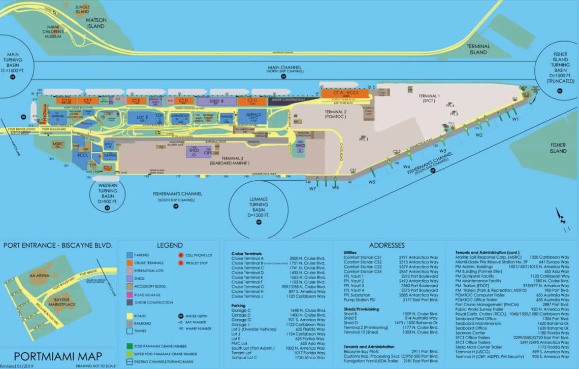
🗺️ Quick Look: PortMiami Terminal Layout (2026)
PortMiami’s terminals line both sides of Dodge Island and are organized so cruise lines can easily assign and direct passengers:
📌 Cruise Terminals at PortMiami
-
Terminal AA/AAA: MSC Cruises (large new facility)
-
Terminal A: Royal Caribbean ships
-
Terminal B: Norwegian Cruise Line (NCL)
-
Terminal C: Disney Cruise Line & MSC
-
Terminal D & E: Carnival Cruise Line, Holland America, Princess, P&O
-
Terminal F: Carnival Cruise Line
-
Terminal G: Celebrity Cruises, Royal Caribbean
-
Terminal J: Oceania, Regent Seven Seas, Azamara & Crystal Cruises
-
Terminal V (old H): Virgin Voyages
These terminals are all in close proximity, with clear walking routes between them — helpful if you need to find shuttle stops or family members docking at different terminals.
Important: A planned Terminal G update is in progress, but final completion is expected around 2027, so maps may change slightly through 2026.
📄 PortMiami Cruise Terminal Map
You can view or download the official PDF cruise terminal map from Miami-Dade County. It shows:
-
All labeled terminals (A, B, C, etc.)
-
Roads and parking garages
-
Port Boulevard and North America Way
-
Administrative buildings and taxi/Rideshare zones
✔ Pro tip: Save the map to your phone before you arrive — cell service near the port can be spotty.
🚗 Driving Directions to PortMiami (2026)
Whether you’re coming from the airport, Orlando, or the west coast of Florida, here’s how to navigate your way:
🚙 From Miami International Airport (MIA)
-
Take I-395 East toward Miami Beach
-
Follow signs for PortMiami / Cruise Terminals
-
Port entrance is at Biscayne Blvd & Port Blvd
🚗 From Fort Lauderdale (FLL)
-
Head south on I-95 South
-
Exit at I-395 East toward Miami Beach
-
Follow port signage to your designated cruise terminal
🛣️ From the West Coast of Florida (Tampa/Central FL)
-
Use I-75 South to I-595 East and then I-95 South
-
Merge onto I-395 East and follow port signs
PortMiami Tunnel: The PortMiami Tunnel (SR 887) connects the MacArthur Causeway to Dodge Island, allowing traffic to bypass downtown congestion.
📍 Parking & Drop-Off Zones
PortMiami has several on-site cruise parking garages and lots adjacent to the terminals. Popular options include:
-
Garage C, Garage D, Garage G, Garage J
-
Lot 2 (oversized vehicles)
Tips:
✔ Arrive early on embarkation day to avoid traffic backups.
✔ Drop-off/drop-off zones are clearly marked near each terminal and port staff assist with luggage.
🚕 Rideshare, Taxi & Public Transit Access
-
Uber/Lyft and taxis can drop you off right outside your terminal entrance.
-
Public transportation (Metrorail, Tri-Rail, Brightline) gets you close, but often requires a short taxi or rideshare for the last mile.
🧠 Embarkation Day Tips
🕒 Arrive Early
Traffic around PortMiami picks up quickly on cruise mornings — arriving 90 minutes before your check-in window reduces stress.
🛂 Know Your Terminal
Confirm your terminal assignment in the cruise line app before you get in your car — signs are clear but terminals line up close together.
📲 Save Key Addresses
-
PortMiami Main: 1015 North America Way, Miami, FL 33132
-
Individual terminals often have slight address variances — check your ticket.
Final Thought
Having the latest maps and directions for PortMiami in 2026 ensures smooth arrival, easy parking or drop-off, and no confusion finding your cruise ship. Whether you’re local or flying in, planning ahead with maps in hand will make your embarkation day stress-free and enjoyable.